Order Digital Reprints
Filed Under
Sign Me Up!
Sign up Digital!
Subscribe to Print!
Interested in Manholes?
Get Manholes articles, news and videos right in your inbox! Sign up now.
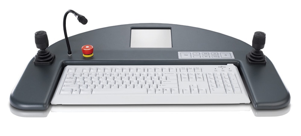
Manholes + Get AlertsInspection controllers
New control units from RapidView IBAK North America communicate with the company’s pipeline inspection equipment and present users with relevant diagnostic and control information on a large color touch screen. The controllers adapt and evolve as needed: Only the appropriate controls are presented to the user, reducing confusion and increasing productivity. Two ergonomic joysticks control tractor and camera functions while lighting, elevator control, reel functions, camera presets, clutch controls, and tractor stability are managed from the central touch screen. An intercom system allows easy communication between the front office and the work area. The control unit, text overlay and system power supply are contained in one unit that mounts in a standard 19-inch component rack. 800/656-4225; www.rapidview.com.
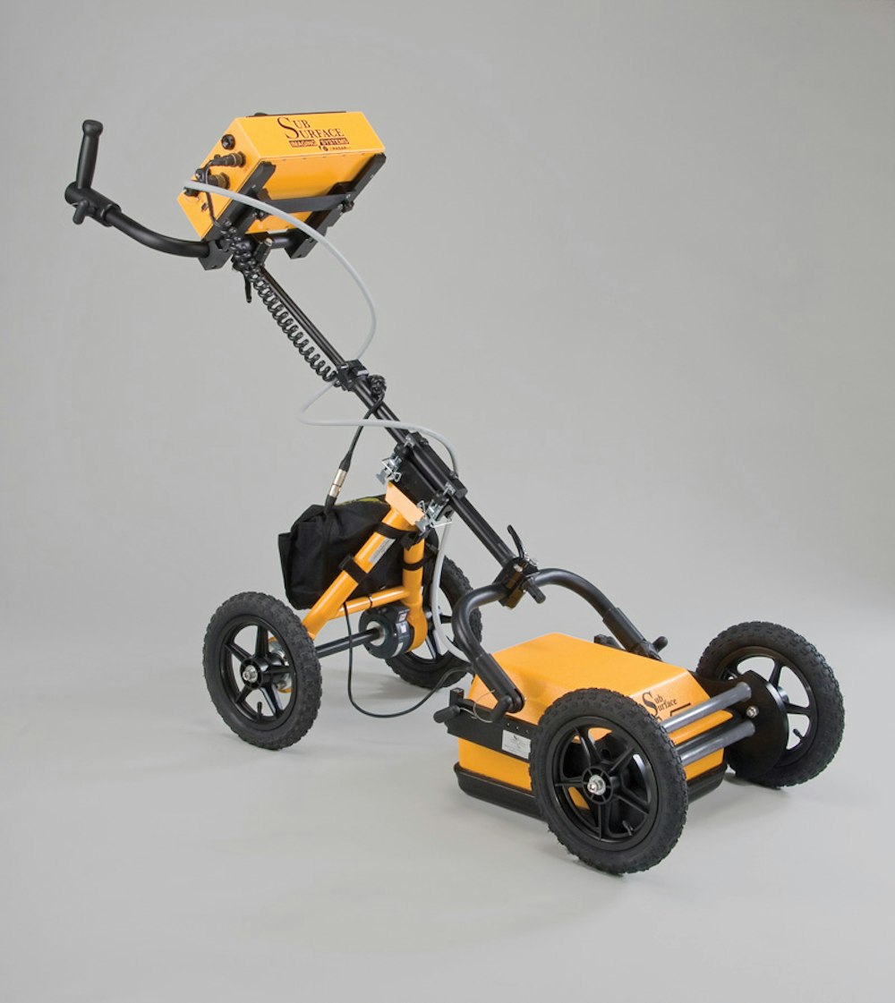
Subsurface radar
The Seeker SPR subsurface penetrating radar system from US Radar is an easy-to-operate unit that can infiltrate surfaces such as soil, clay, concrete and brick. Using a touch screen operating system and a range of antenna frequency options, it integrates a complete imaging system in a portable unit.
By transmitting energy pulses through a variety of media, the system can display an image of the subsurface on the operator interface. Users can set a variety of parameters before each unique survey to maximize efficiency. Parameters including soil settings, algorithms, and color palette can be adjusted using the touch screen. The system can be set to focus on a particular depth range. 732/566-2035; www.usradar.com.
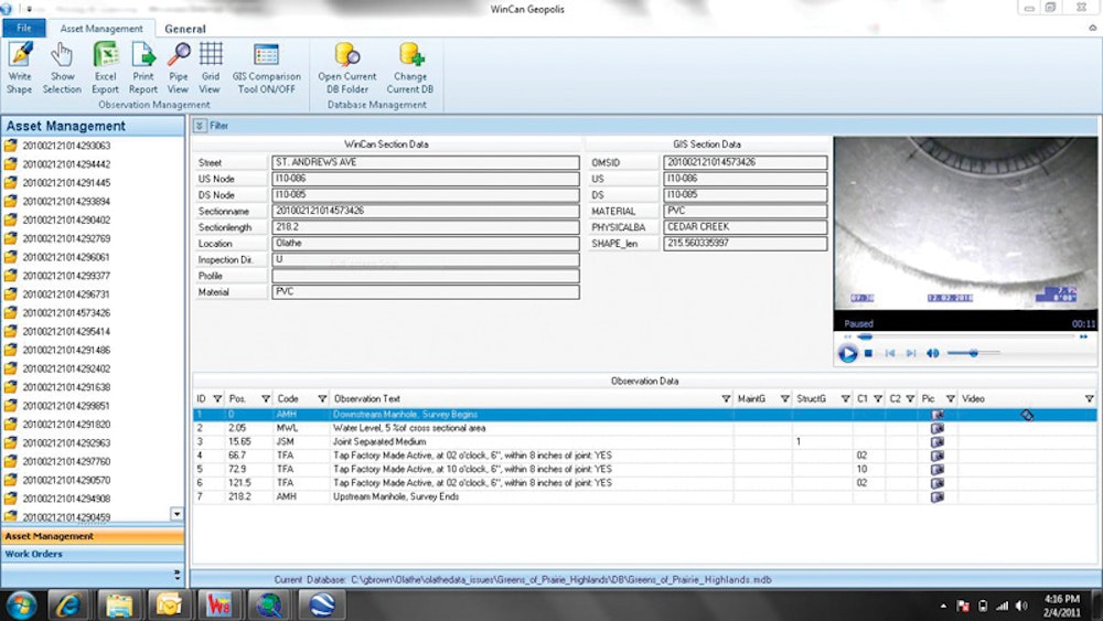
CMOM management
Granite XP v4 condition assessment software from CUES enables utilities and contractors to execute a comprehensive CMOM management program. The software is fully supported for Windows 7 and Esri ArcGIS v10. It uses software-based compression to capture video in MPEG I, II and IV, eliminating specialized hardware components. This also allows all editions of Granite XP to run in the Windows 7 environment and on virtually any vehicle.
CUES, in partnership with IBM Maximo, has released a bidirectional Work Order integration module between Granite XP and Maximo version 6.2 and newer using real-time Web services to initiate and close work orders. Asset information is simultaneously synchronized with GIS for spatial and attribute asset data precision. 800/327-7791; www.cuesinc.com.
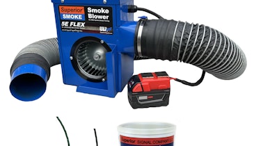
Color inspection system
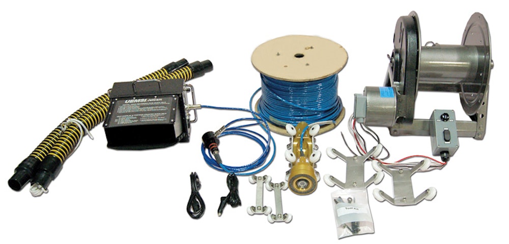
The UEMSI JetCam system works with any style sewer jetter or combination machine, trailer- or truck-mounted. Users can inspect while cleaning and immediately determine if the pipe needs further evaluation or repair. The control unit has a 10.4-inch color LCD monitor and a built-in DVR that records to a CF card.
The mountable reel supplied with the system holds 600 feet of video cable and has a motorized rewind and controller for rewinding. The nozzle body assembly includes a special nozzle that houses the Pro Eye self-leveling color camera and auxiliary lighthead. The system has enough light to televise up to 27-inch pipe. A variety of skid sizes are included. The nozzle jets are specifically drilled for the flow and pressure of the users’ jetter. 800/666-0766; www.uemsi.com.
Service software
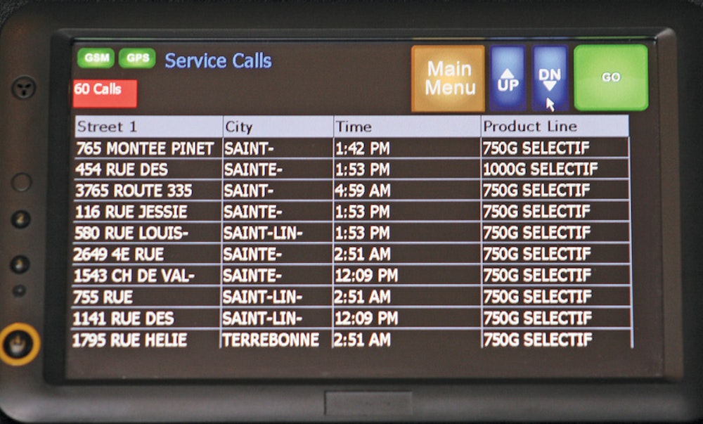
Public Works Management Software from Operasoft, designed with Microsoft Dynamics CRM technology, requires no on-site installation and handles service requests, real-time dispatching, GPS tracking, supplier/contract management, time tracking and more. The MODIS terminal can display employees’ job lists with comments and instructions that pop up by location.
Dispatchers can track progress in real time and view work completion, open/closed service calls and damage reports on Google Earth. Preventive fleet maintenance is managed by creating and tracking vehicle repair work orders; end of day vehicle inspections are entered on the MODIS terminal before the driver parks and exits the service vehicle, automatically creating new repair work orders for the garage as needed. 888/986-7372; www.operasoft.ca.
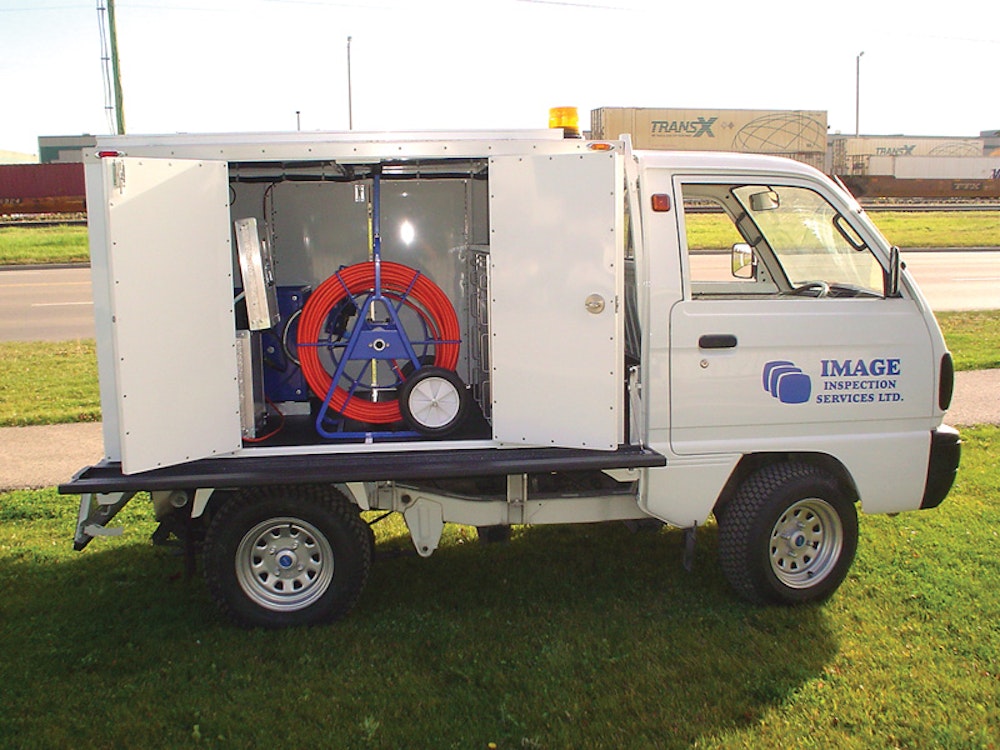
Self-contained inspection system
The Bigfoot all-terrain video unit from Image Inspection Services is a compact, self-contained pipe inspection system for on- and off-road usage. Its lightweight, mini 4x4 chassis with wide, low-impact turf tires traverses sensitive areas with minimal landscape disturbance and noise.
The unit is powered from a self-contained roof-mounted solar panel, charge controller, battery system and power inverter that makes it virtually silent. The video system is housed in a lightweight aluminum box containing camera control panels, cable reels, crawlers and tools. It is available with any type of Image camera system or combination of components. 403/287-1053; www.image-inspect.com.
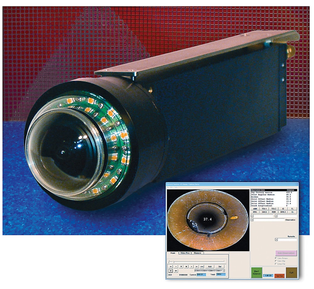
Panomorphic camera
The OMNI Eye 360 panomorphic camera from RS Technical Services is a single-conductor inspection tool compatible with existing RST portable and mainline inspection systems and can be modified for use with most multi-conductor systems. With its continuous 360-degree image capture, it is designed for inspection in lined 6-inch and larger diameter lines up to 2,500 feet long.
Post processing and review can be accomplished in the field or in the office. The captured images are linked with a software package that identifies defects and features. Data capture features include accurate measurements from X- and Y-axis for precision lateral, joint and crack measurement; simultaneous view of forward and unwrapped footage; and auto measurement and distance recognition for optimal observation and defect coding. 800/767-1974; www.rstechserv.com.
Survey software with GIS
GIS capabilities in survey software from PipeLogix helps locate specific pipe defects. By adding the GIS module to ArcMap, users can view all surveys performed on an asset. The toolbar filters survey data in the master database to highlight pipes with problems and lets users select the condition from an exported layer and jump the associated movie to the condition for viewing.
Seeing the problem and where it exists can make it easier to schedule repair and cleaning crews. The Condition export can be performed to a feature class in a geodatabase or to a shape file. Surveys can be created from ArcMap by selecting pipes and creating a project of inspections in the Pipelogix Database for the CCTV inspector to complete. The system is compatible with ArcGIS 9.3 and soon ArcGIS 10.0. 866/299-3150; www.pipelogix.com.
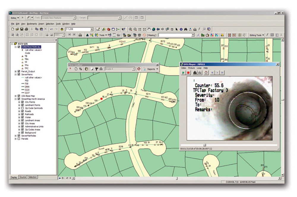
GIS mapping module
The WinCan GIS module for WinCan V8 pipe inspection and asset management software from Pipeline Analytics helps manage water, stormwater and sewer infrastructure using GIS data. Users simply click-and-drag or query a map to create entire WinCan projects with prepopulated section data; automatically create linked map elements from observations; dispatch inspection and repair crews; and augment GIS data with more infrastructure detail.
Users can filter, report, browse media, track progress and create work orders through one intuitive map interface and geo-located observations in a GIS business process. The GIS module supports feature extraction (plotting observations into a GIS as point features with links to videos and photos), revision detection (highlighting differences between GIS and WinCan data), creating reports and exporting data into Excel software, creating pipe-specific repair strategies using observation data, and mission planning (using the GIS to create subsets of data for pipes to be inspected). 877/626-8386; www.pipelineanalytics.com.
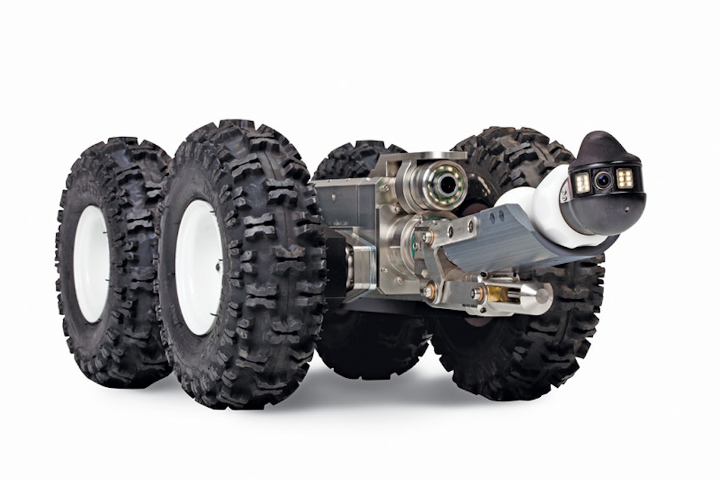
Lateral inspection
Aries Industries has expanded the versatility of its LETS (Lateral Evaluation Television System) by now offering a wheeled version of the lateral inspection tractor. Operators can inspect mainline sewers up to 36 inches while launching into and televising laterals as small as 3 inches. Mainline video is viewed through a fixed-mounted camera on the crawler, while a second camera produces lateral video, viewed most effectively through a PE3600 pan-and-tilt push camera. The lateral camera has a self-cleaning wiper system, enabling users to clean the lens while still in the pipe. An Opti-Launch open-drive system on the tractor can push and retrieve the lateral camera up to 150 feet up a line from the service connection, and up to 1,000 feet down the mainline. The built-in 512 Hz sonde and on-screen footage displays allow for precise aboveground location of observations. 800/234-7205; www.ariesindustries.com.