

Like the basketball teams its state is known for, Mishawaka, Indiana, has changed up its defenses against combined sewer overflows.
Instead of the old grid-mapping system the Department of Sewer Maintenance previously used to clean sewers neighborhood by neighborhood, the city is now using subsystems, cleaning all sewers that flow to a specific lift station, then moving on to the next lift station network.
It’s like switching from zone to man-to-man defense.
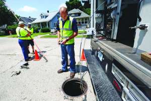
Department Manager Tom Dolly recalls when he started with the department in 2004. “We had a camera truck and two cleaning trucks. Our job was to respond to calls. There would be a backup, and we would go out and clean and jet the line, point A to point B, and then make sure we could run the camera through it.”
It’s different today. Under orders to reduce CSOs to area streams and the St. Joseph River — a prime salmon and trout fishery — Mishawaka is attacking the problem on several fronts and making progress. “On a recent weekend when communities in our area were hit by severe rainstorms and reported widespread flooding, we didn’t have a single emergency call,” Dolly says.
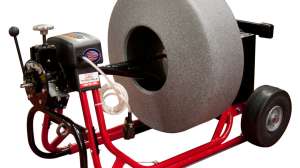
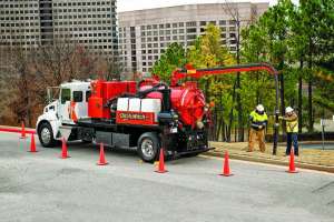
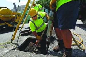
Mishawaka has 19 CSO structures along its 212-mile sewer system. Fifty-eight miles — or 27 percent — of the system consist of combined sanitary and storm sewers. To clean and maintain the lines, Dolly’s team uses two combination trucks — one Vactor and one Aquatech — along with three CUES lateral launch cameras and three push cameras. A Granite XP sewer inspection software package ties everything together.
“We added the Aquatech truck in 2011 and a new Vactor this year,” says Justin Leslie, the department assistant manager. “Each truck has its own purpose and many times can get to spots the other truck can’t get to.”
The battery of cameras includes three CUES OZIII camera heads with two Compact Pipe Ranger Transporter systems, which can deal with lines from 6 inches to 24 inches in diameter. The collection also features a stormwater Mudmaster transporter that uses the OZIII camera head that can run pipes from 24 to 60 inches in diameter. The department has three push cameras, including a fixed head CUES and two cameras from Envirosight. The Cues fixed head is fully compatible with the Granite software package.
The department values the equipment redundancy. “We’re never down,” Dolly says of the assets on hand. “We always have something available; the equipment gets jostled around, hitting roots, making turns, but we’re never out of business.”
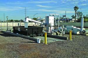
Twenty-nine remote lift stations feed wastewater and stormwater to the city’s wastewater treatment plant, originally constructed in 1952 and expanded in 1999 and 2008. The plant is an activated sludge facility with single-stage nitrification and chemical phosphorus removal. Average dry weather design flow is 20 mgd, with a peak flow of 42 mgd and wet weather capacity of 60 mgd. The plant discharges to the St.Joseph River.
Shortly after Dolly’s arrival, the Sewer Maintenance Department began cleaning its system in a more organized fashion — dividing the 17.8-square-mile service area into a series of 28 box-shaped grids. Using the two combination trucks and the array of cameras, crews would clean and inspect the lines in one grid and then move on to the next.
“It worked pretty well,” Dolly says. “We were able to cover the entire city in about three years, and we were getting the system about 97 to 98 percent clean.”
Then Bill Moody, the department’s GIS coordinator, came up with a better idea. “One of the problems,” recalls Leslie, “was that we would clean a portion of a line but not the entire line, and we might end up just blowing debris from one section into another. We might leave a line half clean and not get back to it for a year or more.
“So Bill developed a specific subsystem layer using the GIS program that mapped our system by sections served for our 29 different lift stations.”
Moody recalls staring at the GIS maps and noting that lines in a particular grid sometimes ran in opposite directions, not even to the same lift station. “We rearranged the grids so they reflected what the sewers were actually doing in the ground,” he says. “We developed a different color for each group. Now we can clean the whole system from top to bottom, no backtracking or going back into lines we’ve already cleaned.”
The new approach enables the crews to completely clean an entire subsystem feeding one lift station. “We’ve only been using the new system for a few months, but we think it will leave our sewer lines even cleaner and reduce the chance of overflows into the river,” Dolly says. “We’ve cut down on CSOs using the grid system, and we expect the new approach will be even more effective. In fact, we’re already experiencing fewer calls.”
Dolly’s 12-man crew is out daily, using both trucks and two cameras, “knocking down as much footage as we can,” he says. “We do a lot of inlet and catch basin cleaning, cleaning off the top, popping the lid and cleaning them out. We patrol up and down, looking at our inlets. They clog with tree buds in spring and a lot of leaves in the fall. The combination truck flushes them out.”
The GIS maps created by Moody also help the maintenance crews spot trouble areas — mainly around restaurants and fast food establishments. “We have special markers for these areas in the map and certain manholes are checked monthly,” Dolly says. “Some are bad enough they need to be vacuumed out every month.
“We do small repairs ourselves, and for larger projects we can go to the Board of Public Works and Safety for competitive bids,” he explains.
Computers — especially GIS — have made the difference in the effectiveness of Dolly’s team.
“This department didn’t have a GIS,” Dolly recalls. “We were using auto cad drawings, and everything was in the wrong place, lines flowing in the wrong direction.
“With GIS, all our flows are in the right direction and pipes are the right size. We are always checking the system found in the field against historic records from which the GIS sewer base map was created. We are very close to completing the verification of GIS for the sanitary system, and about 50 percent on the storm system,” he reports. “We can get into the truck, look at the computer map and select the line we’re going to run. It saves time.”
Plus, he says, when the trucks return, the data can be put into the system and he can look at everything that’s been uploaded, view log reports and watch the videos. “Our inlet patrols scan everything digitally and make that information accessible on the network.
“When we do get a call about a backup in a basement, we can look back and see exactly when and where our crews have been.
“If a homeowner calls about a problem, we’ll go out with our TV unit and a push camera and evaluate the situation for free. They don’t need to call a plumber.
We can see the blockage. Then we’ll come back with the camera and show the video to the resident. It makes the contractor more accountable.”
Improving the efficiency of the sewer system is just one of the strategies Mishawaka is using to reduce CSOs and comply with its consent decree mandates.
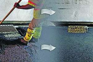
Other measures include improvements at the treatment plant itself, separation of sewers and removal of sewer bottle- necks, constructing parallel interceptor sewers, expanding river crossings, and plans for a large stormwater storage and conveyance tunnel. Also, extensive CIPP lining of formerly combined sewers has significantly reduced I&I, providing more capacity at the WWTP for wet weather treatment.
Karl Kopec, wastewater division manager, explains that the plant has been expanded twice since its initial operation — in 1999 and 2004-08. The expansions have increased flow from the original 8 mgd (peak of 12 mgd) to the current capacity of 20 mgd (peak 42 mgd), with a wet weather capacity of 60 mgd.
“The first expansion reduced our overflows from 300 million gallons a year to 230 million gallons,” Kopec says. The more recent capacity addition has reduced CSOs even further — to around 50 million gallons a year.
A unique step flow design helps the plant handle high flows. As Kopec explains it, the activated sludge system contains a series of gates and concrete baffles.
When wet weather flows hit the plant, the primary effluent is introduced to the system at one of the downstream gates, while the return goes to the head of the system. Solids are sequestered behind the baffle wall. “The process allows us to hold solids and reduce solids loadings on our clarifiers,” Kopec says. “It’s a fairly inexpensive change, and it’s helped our plant perform extremely well during wet weather.”
An underground storage and conveyance tunnel, ending at the plant and extending some 6,000 feet to the east, will provide additional storm flow control.
Kopec says designs are being reviewed this summer, with construction scheduled to start in 2017.
It all adds up to a winning game plan for Mishawaka as it takes on CSOs.
“Our combined effort — with the patrols, flow monitoring and just doing such a better job maintaining our sewer lines — we’re seeing fewer backups and less
CSO discharges to the river,” Dolly says.
Adds Kopec, “Using 1990 as a baseline, we’ve reduced CSOs by 86 percent. Our consent decree calls for zero overflows in a typical year. I’m absolutely certain we can make that goal.”
The St. Joseph (St. Joe) River winds through northern Indiana and southern Michigan farmlands for 206 miles before entering Lake Michigan.
Protecting its water quality from sewer overflows and other forms of pollution is a key to the region’s economy, because the river supports an active salmon and trout sport fishery.
The river was stocked with game fish in 1969, and over the years fish ladders have been installed at dams along the river, allowing the fish to migrate upstream to spawning areas. The fish ladder at Mishawaka was completed in 1991 and includes a viewing port where fish can be seen and counted moving upriver.
The St. Joe River Fishery project is one of only a handful of interstate fishery projects in the United States. Economic impact to Mishawaka and other river communities is estimated to be in the millions of dollars annually.
It’s not uncommon for residents to have to cough up a large amount of money to pay for repairs to sewer lines running from their property to the street. Often, they think the sewer utility is responsible for the lateral, only to discover that the bill is theirs to pay.
In Mishawaka, Indiana, however, residents are protected against catastrophic sewer repair costs through an innovative insurance program.
As part of their regular sewer bill, homeowners pay $1.50 a month into a sewer insurance fund. The fund pays all costs in excess of $250 that are directly attributable to the repair of a private sewer lateral connection between the foundation wall of the home and the city’s trunk sewer line. The fund also covers all costs associated with the removal and replacement of public streets, curbs and sidewalks as a result of the repair. If the situation simply requires routine cleaning or maintenance, the homeowner is responsible for that cost.
Tom Dolly, manager of Mishawaka Department of Sewer Maintenance, reports that in 2014 there were 43 calls from residents concerning sewer lateral issues. A little more than half of those incidents qualified for repair under the insurance program. Total payout from the insurance fund was just over $180,000 — or about $7,800 per project.
Continue reading for free