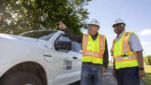
The New York City Department of Environmental Protection recently announced that it will launch a remote operated vehicle (ROV) to assess previously identified leaks in a portion of the Catskill Aqueduct that runs several hundred feet below the Rondout Creek in Ulster County.
The vehicle, a remotely operated submarine, will use high-definition video cameras, acoustic equipment and other instruments to examine this portion of the aqueduct, known as the Rondout Pressure Tunnel. Data gathered through that analysis will be used for the final design of any necessary repairs to the leaks in a project slated to begin in 2027 following other requisite repairs in the water supply system, including the ultimate completion of the Delaware Aqueduct Bypass Tunnel under the Hudson River.
What is the Rondout Pressure Tunnel?
The Rondout Pressure Tunnel is a 14.5-foot diameter pipe that stretches 23,608 feet from a wooded area north of Stone Ridge to a site within the Mohonk Preserve. Water within the Catskill Aqueduct travels at ground level before it enters the pressure tunnel, which plunges approximately 500 feet below the surface to convey that water under the Rondout Valley. It then rises back to surface level on the eastern side of the valley, where the water continues its journey south to Kensico Reservoir.
The Rondout Pressure Tunnel is the longest of the pressure tunnels that allow the Catskill Aqueduct to carry drinking water beneath broad valleys that include creeks or rivers. Other pressure tunnels of the Catskill Aqueduct carry water below the Wallkill River, Moodna Creek/Hudson River and New Croton Reservoir.
Pressure tunnels comprise about 15% of the total length of the 92-mile Catskill Aqueduct. About 55 miles of the aqueduct were built through “cut-and-cover” methods, where a trench was excavated and the aqueduct was built at the surface. About 14 miles of the aqueduct are grade tunnels that were cut through hills or mountains. Through the cut-and-cover and grade tunnel sections, water inside the Catskill Aqueduct is not under pressure; rather, water inside the aqueduct flows like an enclosed river. The remaining 23 miles of aqueduct is comprised of pressure tunnels and steel pipe siphons that plunge downward into the earth and then return to surface level. In these sections, the aqueduct is under great pressure from water pushing down on itself and outward on the aqueduct walls.
Rondout Pressure Tunnel leaks
The New York DEP has determined through a prior ROV flight that the Rondout Pressure Tunnel developed leaks in at least three locations. One of the leaks, at a valve in a drainage shaft connected to the tunnel, was repaired during a separate recent rehabilitation project of most of the cut-and-cover sections of the aqueduct.
That leak was repaired during one of several shutdowns of the aqueduct between 2018 and 2020 during what was known at the Catskill Aqueduct Repair and Rehabilitation project, which included the removal of biofilm from inside the aqueduct and replacement of numerous century-old valves connected to the aqueduct.
In addition to the drainage shaft chamber, other leaks in the Rondout Pressure Tunnel have created surface expressions on land in the vicinity of the tunnel.
Investigating additional leaks and designing a repair
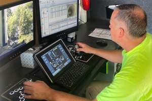
Starting in late November, the DEP gradually started shutting down the Catskill Aqueduct and ultimately will send the ROV through the Rondout Pressure Tunnel to re-examine the leaks. The ROV will be connected to a long wire that will transmit high-definition video, acoustic information and other data back to a work trailer. Cameras and lights will be positioned around the entire circumference of the vehicle to gather a 360-degree view of the tunnel. In areas where a leak is suspected, food dye might be injected to help engineers see whether it leaves the tunnel through a crack, indicating a leak location.
Data gathered by the ROV will take many months to analyze before engineers can draw accurate conclusions about the current day condition of leaks, as well as determine potential repairs.
The United States Geological Survey has separately conducted studies monitoring the leaks by reviewing water level trends in participating private water wells throughout the town and what affect the leaks might have on local groundwater levels.
Data gathered by the ROV and the USGS will inform the design of a permanent repair for the leaks. The repair work will likely be complex because the deep-rock tunnel always remains filled with water, is always under pressure, and no mechanism currently exists to pump it dry. A method for pumping the tunnel dry and entering it safely will likely need to be incorporated in plans to fix the leaks.
Continue reading for free