


When the City of Fort Worth, Texas, reorganized its approach to stormwater management nearly 10 years ago, it didn’t just save money or prevent property damage. It saved lives.
Repeated heavy storms that overpowered the city’s stormwater drainage lines and produced flash floods were a chronic – and sometimes a fatal – problem in the city. Officials recognized the trouble, but resources for anything but the immediate fix were scarce.
Since 2006, however, the system has undergone a complete turnaround. Stormwater management has become a major priority, and the city has invested people, management tools, technology and money to make that happen.
Fort Worth did that by creating a dedicated stormwater management utility within city government and funding it with fees collected from property owners.
Until then, stormwater management operations were “completely reactive,” says Greg Simmons, assistant director of the Fort Worth Transportation and Public Works Department, and chief of the department’s Stormwater Management Division. City workers responded when inlets clogged and water backed up to flood roads, for example – but only after the fact.
“Now we’ve got a very proactive process,” Simmons adds. “Before, we were waiting for people to call and complain. Now we’re getting out, studying problems and putting plans together to fix them.”
With only two or three big rains a year, stormwater management “was an easy thing to ignore,” Simmons says.
As the city grew, the system didn’t keep pace with the increase in pavement and other impervious surfaces from development, all of it increasing the need for drainage.
But big storms and recurring flooding damaged property and took a grimmer toll. Storms turned fatal with gruesome regularity.
Since 1986, 17 people have died in flooding-related episodes in the city, according to information from the division. But a sign that there’s been progress is that the last such known death was seven years ago, in March 2007.
After a 2004 storm in which a mother and her two children drowned in their car, the City Council directed a committee of city employees, property owners and others to explore solutions. The panel hired a consultant and came back recommending the creation of a separately funded stormwater utility. That was launched in the spring of 2006.
The stormwater utility remains part of the city government, but its budget comes from a dedicated enterprise fund paid for by a monthly stormwater fee, included with the monthly water, sewer and garbage-collection fees.
The stormwater fee is billed in increments of $5.40 a month per 2,600 square feet of impervious surface on a property (typically pavement and roof). Residential owners are billed in four tiers, ranging from a half-unit ($2.70) to a double unit ($10.80), based on their home size.
All other properties – businesses, most nonprofits and even churches – are assessed at $5.40 per 2,600 square feet, based on their total impervious square footage. The only exception has been private colleges, which are waived under a provision in Texas state law.
With funding in place, the next step was a review of the entire system, identifying where repairs were needed and infrastructure should be beefed up.
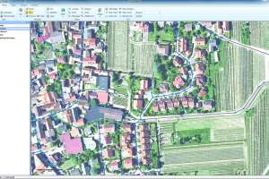
Existing paper records were a start, but some were unreliable and incomplete, Simmons says. With the aid of a consultant, the utility invested $11 million to map the system, identifying all of the assets and putting relevant data into a geographic information system.
“We’re trying to work toward a true asset management system,” says Elizabeth Young, who runs the utility’s GIS program. Workers collect information to establish the life cycle of each asset, “so that we know the best time to rehabilitate and replace things.”
The system has 36,460 stormwater inlets or catch basins, 930 miles of pipe and 930 miles of open-air channels and creeks. There are also 5,007 infalls, 9,377 outfalls, 26 miles of drains and 41 miles of flumes. Most of that has now been mapped to the utility’s GIS asset registry.
The records include physical specs such as pipe width, diameter, length and composition. For surface assets, records include photographs and links to the original construction plans. For open-air channels, the records show what they are lined with – stone, riprap or other materials.
GIS asset records also list details such as the installation date, the asset’s maintenance history, even how much time had to be spent for various repairs and procedures on the component; that enables the utility to make better cost projections for repairs.
Information from the mapping survey was used to pinpoint and prioritize specific locations where the most urgent drainage problems were: how many people could be affected, how deep floodwaters could get and how much traffic disruption might occur.
The division’s engineering planning group developed and regularly updates a master plan that is used to shape the capital program.
“We’re trying to find the sweet spot between those things that are technically feasible, acceptable to the community and affordable,” says Chris Johnson, engineering manager.
Computer models help analyze various areas around the city to further refine priorities.
Even before the creation of the utility, some capital projects were already underway. “When the utility was created, that accelerated greatly,” says Linda Young, capital projects program manager.
The division has identified fully $1 billion worth of projects and is working through the list as resources become available, she says. Bond issuances since 2007 have generated a total of $150 million to fund projects.
Additional capital funds have come out of the annual operating budget. Those have tended to be small projects, but the utility is looking at how it might put more capital funding on a pay-as-you-go basis so it relies less on debt.
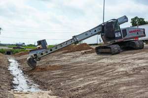
Projects have ranged from replacing undersized storm drains with larger units, to rebuilding water channels and replacing aging culverts to reduce the chance of floodwaters overtopping roadways.
“When a road becomes covered with water after a storm, drivers don’t have any way to gauge how fast it’s moving,” Linda Young points out. “If they’re driving over a creek or a stream, they can be washed off the road and perish.” Even motorists who survive such an event may be stranded, their vehicle ruined, she adds.
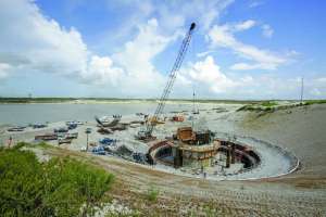
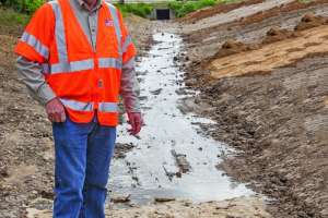
And there have been larger and more complex projects too. One was at the intersection of Butler and McClure streets in Fort Worth. A creek meanders through the neighborhood, crossing Butler at one point and McClure further downstream, says project manager Michael Owen.
In an April 2004 storm, a truck passed through a flooded street safely, Owen says, but a car that followed was swept off the road into a channel and down a creek. The woman driving and her two small children died. Two months later another storm flooded the area and swept a car into the channel. The driver of that car was able to get out safely, but the car was lodged at a culvert.
McClure Street was closed and remained so until late last year, when the $1.75 million repair to the area was complete.
The project, which began in January 2012, included raising an intersection about 8 feet out of the flood plain, adding a concrete relief channel, improving the existing culvert, and constructing one 12-by-8-foot and five 10-by-10-foot culverts to replace much smaller culverts that weren’t adequate to contain floodwaters in severe storms.
For parts of the city prone to flooding that haven’t yet been reworked, Fort Worth has been installing early warning signals on roadways. The signs and lights alert drivers when water is topping the road surface and direct them to take an alternate route or turn back, says Johnson. A total of 53 locations around the city have warning systems.
Water and sewer lines in the area were also replaced. The city looks for opportunities to coordinate with projects among the various public works divisions so that excavators only have to dig once. “Almost all of our projects affect the street portion, and street improvements are part of them,” Owen says.
The project won an award from the Texas Public Works Association in the under $2 million category.
“It really transformed the area out there,” Owen says. “It doesn’t look anything like it did before.”
In another project, the Stormwater Division built a multi-use stormwater retention basin in a neighborhood subject to recurrent flooding. The basin was built on the property of Eastern Hills Elementary School in a once-wooded area. After it was built, the land above the basin was made into a practice field for sports teams.
The basin is designed to fill up with water and release it slowly into the stormwater drainage system, Owen explains. The underground design allowed for landscaping that made it more aesthetically pleasing and created the practice field as a bonus amenity.
Another phase is underway and a third, which will involve additional storm drain construction, is planned for the area.
For both larger projects and day-to-day work, the GIS database can now give field crews just about all the information they need on the assets they’re called out to troubleshoot, says Elizabeth Young.
The GIS program is linked to Google Maps so that workers can get a street-level view of the location. “We’re trying to prevent as many trips to the field as we can,” she says.
Last year the utility launched its Work Order and Asset Management System project, using asset management software from Accela Inc. in San Ramon, Calif. The system links directly to the asset records. In the field, crews can view the records on ruggedized tablet computers running Microsoft Windows 7.
They can also record information about their jobs while still at the site, such as how long a task took. By measuring the project time against wage rates, “we have an idea, on average, of what it costs to clean an inlet going forward,” Elizabeth Young says.
Thanks to the system, she says, the utility’s inlet cleaning program was able to do away with 2,400 paper maps it used to generate each year. Crew members fill out daily work logs on their tablets. “That was another 1,000 sheets of paper a year that we reduced.”
The system also makes it easier to tell when a particular site has a recurring problem. Simmons explains that figuring out where the system demands more resources “points us to understanding that maybe we need to replace something.”
System maintenance is organized by asset categories, including underground pipes; concrete fixtures, mainly inlets; channels; and other fixtures: infalls, outfalls and flumes.
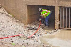
Channel maintenance is the work of two crews totaling nine employees. Their work includes clearing out sediment that can fill up channels and cause localized flooding. Earthen channels eroded by flowing water need to be reconstructed. In concrete-lined channels, sections of broken or damaged concrete require repair or replacement.
“Until the utility was created we had never had the resources to restore those channels to their design condition,” says Juan Cadena, field operations director.
The inlets are cleaned on a routine cycle. “The goal is to do 7,000 a year and cycle through our entire system in five years,” says Vince Elias, field operations supervisor.
For the underground pipe, the city has been contracting with inspection companies to identify its condition and locate problem areas.
“We’re finding all kinds of issues,” Cadena says. Work crews are assigned to go in and make repairs as quickly as possible.
Bigger responsibilities and more organization demand bigger budgets. Before the creation of the utility, Simmons says, the city spent about $6 million a year on operations related to stormwater and $3 million on capital improvements. For fiscal year 2014, the operational budget will top $35 million and the capital budget $12 million.
“There’s been a very dramatic improvement based on having some resources to do things,” Simmons says.
But the Stormwater Management Division’s preferred metric is to track the impact of its maintenance and improvement work, not just count the dollars or man-hours spent on a project, Simmons says.
By that measure so far, “We’ve protected over 300 properties that were subject to flooding.”
Accela, Inc. - 888/722-2352 - www.accela.com
Continue reading for free