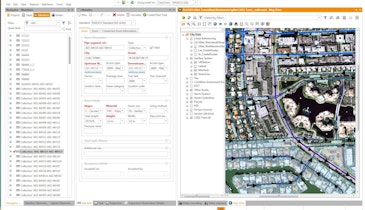
GraniteNet v2.4 from CUES enables data fusion with the ability to aggregate multiple types of inspections, conducted at different times, into a single view for each asset so that superior assessment with advanced scoring can be made to measure an asset’s remaining useful life and accurately estimate its repair/replacement schedule. Built with Microsoft and Esri ArcGIS components, it has bidirectional integration with work order management systems such as IBM Maximo, Azteca Cityworks and Infor’s Hansen. Users can easily click on a map, start and complete an inspection, upload it to the office and make it available to authorized reviewers via the gNet Web portal through a browser over the Internet. 800/327-7791; www.cuesinc.com.
Software - CUES GraniteNet v2.4
Related Stories


Discussion
Comments on this site are submitted by users and are not endorsed by nor do they reflect the views or opinions of COLE Publishing, Inc. Comments are moderated before being posted.