Utility locating combines science with art. Among the biggest challenges is locating nonmetallic structures, such as plastic pipes installed without tracer wires or with such wires that have corroded away or lost their connections.
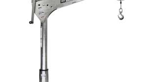
The Innspector 07 locator from SubSurface Instruments Inc., of De Pere, Wis., is designed to let municipal and utility workers find pipes and other structures almost regardless of material: metal, concrete, plastic, clay and others. It is a light, handheld device that requires no calibration and the bare minimum of operator adjustments.
The manufacturer says the unit can find essentially everything that can be located with current technologies, such as magnetic and radiofrequency locators, metal detectors, and ground-penetrating radar (GPR), as well as objects those technologies cannot find. Ron Davenport, president of SubSurface, demonstrated the unit April 1 on grassy right-of-way near a busy intersection in a commercial district of De Pere, Wis.
Walk-around
The Innspector 07 unit is designed to locate structures to a maximum depth of 12 feet. The locator comes in a soft case with form-fitting protective foam padding. The device weighs 2.5 pounds. Its blade-like housing is 15 inches wide at the maximum and 1 1/2 inches thick (tapered to 5/16 inch at the leading edge).
Power comes from four size-C alkaline batteries that go into the handle as they would into a standard flashlight (via a screw-off cap at the handle’s end). The transmitter and two pairs of receiver antennas are built into the plastic housing. The unit is fully self-contained — no wires, clamps, stakes or separate transmitter are used for locating. The unit comes completed tuned and calibrated from the factory.
“This is not GPR,” Davenport says. “Radar sends a signal that bounces back and is timed. This technology is similar only in that it sends a signal out and receives one back. Unlike GPR, this technology is not encumbered by moisture or clay.”
The operator holds the device with the leading edge facing down. From that position, the simple display system is clearly visible. The transmitter signal issues from the center of the leading edge. A pair of receiver antennas is located on each side of the blade-like housing, each pair corresponding to one of two red LEDs.
The transmitter sends a very thin inverted V signal that consists of a proprietary signal technology inside an extremely-high-frequency (microwave range) carrier wave. The technology is designed specifically to locate edges of objects in the ground.
If the right-hand receiver antennas detect an edge underground, the right-hand red LED lights up. The same is true for the left-hand antennas and red LED. When both red LEDs light, that indicates both receivers are aligned with the same edge of the target. An audible signal sounds, indicating that the unit has “locked on.”
In that condition, a red laser light places a spot on the surface, indicating a direct line to the target. That spot then can be marked with paint for reference.
The only other items on the display system are an on/off/sensitivity switch with three sensitivity settings, and a green LED that lights when the unit it turned on.
Operation
For the demonstration, Davenport drove from the SubSurface office and factory to a commercial intersection, an area used often to show the locator’s capability to customers because multiple utility lines pass through it.
Davenport turned the unit on, and the green LED lighted up. He then demonstrated the sensitivity switch. The first position (3) gives the strongest signal and is used to detect objects at the maximum depth of about 12 feet. This helps ensure for safety reasons that operators do not miss any utilities in the area.
The next position (2) delivers about half the signal strength so that the unit looks down 6 to 8 feet. The last setting (1) reduces the strength by half again so that the device looks down about 4 feet. “If you know your target is only 3 or 4 feet deep, you can put the unit on the low setting and eliminate those objects you don’t want to see that are much deeper,” Davenport notes.
The key to using the locator is to have a general idea where the target lies. Davenport pointed out a telecommunications pedestal and the probable route of a cable across a grassy area near the intersection. He slowly walked in a path roughly perpendicular to that route, holding the locator’s leading edge down as he approached it.
The right-hand red LED then lighted up, indicating that it had located an object likely to be the cable. Stopping, he turned the locator slightly clockwise, until the left-hand red LED also lighted, indicating that the unit was parallel with the cable. The audible signal came on, and a small red laser spot appeared on the brown grass. In actual field work, that spot most likely would be marked with paint or with a small flag.
Davenport then demonstrated the step-and-scan method most commonly used with the device to trace a line. He took a few sideways steps along the probable cable route and repeated the scanning procedure until the device “locked on.” Another paint mark or flag would have been placed at that spot. He repeated that procedure a few more times, creating a series of points by which the line could be traced.
Davenport then repeated the procedure with a water line and a gas line. Back at the SubSurface facility, he demonstrated in a test bed that the same procedure could be used to locate buried plastic pipe.
Observer comments
It was easy to see how this unit could be used to locate buried utilities easily. Operators, especially those with locating experience and the ability to visualize underground infrastructure, could adapt to the technology with little difficulty. The unit’s compact size and light weight appear to make it highly portable and comfortable to use in the field without fatigue.
While able to locate a wide variety of materials, the unit does not indicate the depth at which targets are found. In addition, because of the scientific instruments the housing contains, the unit requires somewhat careful handling and should not be used in adverse weather.
Manufacturer comments
Davenport notes that when it is necessary to determine the depth of a target, a simple triangulation method can be used in many cases to provide a reasonable depth estimate. First the operator uses the step-and-scan method to find the target while holding the locator at a 45-degree angle. The spot of the laser point on the ground is marked.
Next the operator goes to a point where he believes the target is directly below and detects the target with the locator in the vertical position. Again, the spot of the laser point is marked. The distance between the two spots is the estimated target depth.
Davenport states that the close-fitting foam in the carrying case protects the unit effectively, but that it should not be carelessly tossed or dropped, even when in the case. He advises against working with it in the rain. If is does get wet, he advises drying it before putting it away. “People have to understand that this is a device that will find things nothing else will find,” he notes. “They just have to take care of it a little better than they might take care of other instruments.”
Davenport notes that an operator with field experience can use the locator to find a wide variety of objects. That includes tracing the perimeters of structures such as septic tanks or vaults. “If you can imagine in your mind the object you’re looking for in two dimensions, you can define it very accurately,” he says. “The more you use it, the more proficient you become.”
Continue reading for free