NASSCO committees are rapidly becoming one of the most important reasons trenchless professionals join NASSCO, following closely behind education and networking. The reason? Because NASSCO committees set goals, members roll up their sleeves and work gets done. A perfect example of this is a recent accomplishment of NASSCO’s Software Vendor Committee.
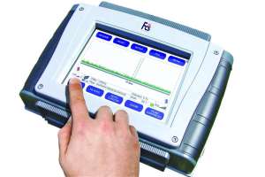
Two years ago, the committee set a goal to find better ways to manage PACP (Pipeline Assessment Certification Program) data. Since then it has worked tirelessly in partnership with the Environmental Systems Research Institute Inc. (Esri) to collaborate on the incorporation of PACP data and code structure for storage of condition and asset information in geographical databases. As a result of this hard work, in 2014 Esri released its ArcGIS for Water Utilities CCTV Processor, which uses a PACP transfer database to display conditions on a map that can be used online. The processor shares observation locations, photos and videos and brings together applications, tools and maps in an extremely user-friendly format.
CCTV and inspection information is now readily available to anyone within a city or utility company. People of all skill levels have the ability to view the information, which is presented in a simple and easy-to-use format, making it even more valuable. There is no longer a need to go to specialized websites or understand data structure. A user can just go to a map, search for a subdivision, or go to a folder and look for CCTV projects. The user then easily discovers where structural defects, construction features and other observations have been recorded.
NASSCO’s mission is to set industry standards for the assessment and rehabilitation of underground infrastructure, and our new partnership with Esri helps spread standards via the most extensive GIS software in the world. This partnership helps us accomplish our goal to ensure work is done right, since data for the assessment of underground pipes is now available to municipal GIS workers so they have the correct codes readily obtainable from the beginning of each project’s assessment. This further helps ensure that underground rehabilitation projects are successfully completed, which will ultimately support the acceptance and growth of trenchless technologies, overall.
NASSCO’s Software Vendor Committee will continue to work with Esri to ensure standards are met and cities and contractors are maximizing their ability to download the data, build upon it and use it as a basis for their assets.
If you would like to know more about NASSCO’s Software Vendor Committee or any of our other active committees, visit www.nassco.org, or join us at our annual conference in Savannah, Ga., Feb. 11-13. The conference is open to all NASSCO members and will include a golf tournament, welcome reception, general membership meeting, committee meetings and a dynamic Technical Day which will include two technical tracks: Safety, Risk Assessment and Municipal Issues; and Collection System Inspection, Maintenance and Rehabilitation.
The conference will conclude with an awards banquet on Friday night. If you are not yet a NASSCO member, please visit www.nassco.org and apply today. To view Esri’s ArcGIS for Water Utilities CCTV Processor, visit http://solutions.arcgis.com/utilities/water/help/cctv-processor/.
Continue reading for free