Stormwater systems operate under conditions that change constantly with weather, terrain, and development patterns. Every rain event introduces a new combination of flow velocity, debris movement, and hydraulic pressure. What appears at the surface as a minor nuisance, such as a slow inlet or shallow pooling of water, often reflects deeper activity within buried infrastructure. Understanding how water behaves inside stormwater networks allows crews to interpret these signals and prevent failures before they spread.
One of the most important distinctions to understand is how stormwater systems differ from sanitary systems. Stormwater networks experience sudden, unpredictable surges that depend entirely on rainfall and surface drainage patterns, while sanitary networks handle steady, regulated flow.
Communities that maintain reliable stormwater systems tend to operate with a forward-looking mindset. Instead of waiting for a culvert to fail or an intersection to flood, they monitor long-term trends in sediment buildup, structural change, and hydraulic capacity. These practices support the same philosophy found in many proactive stormwater programs, where consistent oversight reduces emergency repairs and improves long term system resilience.
GIS has become a central tool in understanding these systems. Stormwater networks do not behave linearly. Water moves across basins, follows grade, enters multiple inlets, and travels through pipes and culverts of varying shapes and materials. GIS reveals how these assets connect and how flow conditions shift across a region. These workflows appear in many examples of GIS-driven stormwater planning, where maps help identify high risk crossings, sediment prone areas, and locations that respond poorly during severe weather. When inspection data links to GIS, agencies gain a single source of clarity that supports planning and maintenance work across all departments.
Stormwater teams increasingly rely on pipe inspection software to organize these insights, allowing inspection data, videos and condition ratings to sync directly with GIS so trends in flow behavior and structural health become easier to track across seasons.
How stormwater systems behave during real field conditions
Stormwater systems must adapt to a wide range of environmental conditions. During a light rain, flow may remain shallow and predictable. During rapid storms, however, water can enter the network faster than expected, carrying sediment and debris that change how water moves through the system. In areas with steep grades or limited inlet capacity, flow can enter pipes at high velocity, creating turbulence that accelerates wear.
Catch basins and inlets are among the first points in the system where problems begin to show. Leaves, trash, silt and organic material accumulate inside these structures, reducing hydraulic capacity. When inlets cannot capture enough water, runoff spills across roadways or into adjacent properties. Crews who track inlet behavior over time can identify patterns such as recurring blockages, shallow sump depths, and problem locations near schools, commercial corridors, or heavy traffic zones.

Buried pipes and culverts carry water beneath roadways and natural channels. These structures face constant pressure from soil, traffic loads, and flowing water. Metal culverts may corrode along the invert. Concrete may show cracks, joint separation, or loss of bedding support. Even small defects can grow when multiple storm events expose a pipe to rapid flow changes.
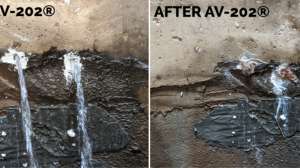
Outfalls serve as discharge points where water leaves the stormwater system. Erosion around outfalls is one of the clearest signs of concentrated flows. When erosion is left unaddressed, surrounding soils weaken and may threaten nearby infrastructure. Crews who routinely monitor outfalls can spot early signs of head cutting, bank instability, and scour.
Understanding how these assets respond to different storm conditions helps crews interpret what they see in the field and prioritize inspections.
Why stormwater systems fail
Several consistent factors contribute to failures in stormwater infrastructure. Recognizing these drivers helps cities plan inspections based on risk and not just on convenience.
1. Aging construction and material degradation
Many stormwater structures were installed decades ago. Older metal culverts experience long term corrosion, especially in areas with acidic soils or frequent moisture. Concrete structures may show cracking, surface deterioration, and separation at joints. Once the structure weakens, the loss of support can accelerate.
2. Sediment and debris buildup
Stormwater systems collect everything that flows across the surface. Sediment is one of the most common contributors to reduced capacity. When sediment settles inside a pipe or culvert, the effective diameter shrinks, which increases the velocity of water during storms. Higher velocity increases turbulence, which encourages even more sediment to accumulate. This cycle worsens over time unless cleaning is performed regularly.
3. Erosion and soil migration
Erosion affects both buried and surface structures. Soil movement around culverts can occur during heavy rainfall or due to long-term shifts in groundwater. Once soil begins to migrate away from a structure, small voids form and expand gradually until the structure loses support. In severe cases, this leads to surface depressions or roadway collapse.
4. Unmapped or forgotten assets
Many communities still rely on stormwater infrastructure that was never fully documented. Older neighborhoods may contain culverts, private drainage features, or abandoned pipes that do not appear in current maps. These assets typically receive no inspection until a failure draws attention to them. Updating the GIS inventory is one of the most beneficial actions a community can take because it reduces the likelihood of hidden risks.
5. Increasing frequency and intensity of storms
Modern weather trends show that short, intense rainfall events are becoming more common. These storms push stormwater systems to their limits. Inlets may overflow. Channels may erode. Pipes may carry far more water than their original design anticipated. Over time, repeated exposure to these conditions accelerates system degradation.
How to organize a stormwater inspection program
Stormwater inspections should be structured around risk, not just around convenience. A strong program identifies where failures are most likely to occur and directs resources accordingly.
1. Prioritize roadway crossings
Roadway crossings are among the most important assets to inspect because their failure has immediate consequences. A culvert beneath a major roadway carries not only stormwater but also the responsibility of supporting vehicles above it. Any movement in the soil, cracking in the structure, or unusual deformation deserves prompt investigation.
2. Focus on flood-prone areas
Locations that experience recurring flooding provide valuable clues about upstream conditions. Flooding may indicate an undersized pipe, a clogged inlet, or an upstream blockage. Inspecting both upstream and downstream assets helps crews determine whether the problem arises from capacity limitations or maintenance issues.
3. Review older infrastructure
Pipes and culverts installed more than 30 to 50 years ago should be prioritized for routine inspections. Older structures generally show more corrosion, cracking or material fatigue.
4. Fill in inventory gaps
Assets with unknown condition or material type represent hidden risk. Communities that take time to verify these assets through visual inspections or CCTV assessments often uncover significant system vulnerabilities.
Field inspection techniques for stormwater systems
Stormwater inspections rely on a range of tools to assess conditions accurately.
CCTV crawlers allow crews to view the interior of pipes and document structural concerns. Zoom cameras are useful for quick surface level inspections of inlets and manholes. Walk-through inspections provide direct observation in larger culverts where safe access exists. Drones and remote vehicles support inspections in long or hazardous structures. Water level sensors help monitor flow during storms and reveal how well the system handles peak intensity.

Inspection findings are significantly more valuable when they connect to GIS. By linking photos, videos and condition notes to mapped assets, crews can visualize relationships between structures and identify where system wide issues may be developing. These capabilities support both routine maintenance work and long term planning.
How data supports stronger stormwater management
Inspection data provides insight that crews cannot see during daily operations. Over time, records reveal patterns that indicate deeper system issues. Repeated blockages in a single pipe may point to upstream grading problems. Structural concerns in a particular material type may signal widespread aging. GIS maps bring these patterns to life and help leaders allocate resources where they are most needed. That is where pipe inspection management solutions like ITpipes SmartVision come in.
SmartVision combines FieldVision and CoreVision to deliver a unified inspection experience that connects the field to the office. FieldVision supports crews in conducting inspections using a map-centric interface that includes live video, historic inspection data, and GIS layers — even while offline. This is especially important during storm events, when teams may be working in remote areas with no connectivity but still need to verify inlet conditions, catch basin blockages, or culvert flow.
CoreVision gives supervisors, engineers and other office personnel instant visibility into field activities and conditions. As inspections sync from the field, CoreVision maps update in real time — color coding assets by structural condition, maintenance need, or inspection status. For agencies managing hundreds of miles of storm drains, this centralized view helps prioritize repairs and cleaning based on actual data, not guesswork. Filters and reports make it easy to generate maintenance schedules based on rainfall history, asset age, or last inspection date, which is critical for prioritizing flood-prone areas or at-risk road crossings.
Inspection software solutions like SmartVision create a closed loop of data capture, analysis, and action. Inspection results are immediately visible, easily filtered, and linked to mapped assets — allowing cities to transition from reactive responses to proactive maintenance planning. Whether responding to erosion at an outfall, identifying a blocked culvert, or verifying sediment buildup in a downstream pipe, these tools support faster decisions, fewer surprises, and a safer stormwater system overall.
Turning inspection results into action
Inspection data becomes most useful when it informs maintenance decisions and operational planning.
Immediate maintenance needs: Some findings require quick action. These include blockages that prevent flow, erosion near structural components, and inlet failures that threaten roadway safety. Addressing these issues early prevents larger emergencies.
Routine cleaning and targeted repairs: Many stormwater issues can be managed through regular cleaning. Sediment prone areas should be identified and added to a scheduled maintenance cycle. Structural repairs that are not urgent can be organized by watershed or neighborhood for efficient project planning.
Long-term capital improvements: Larger structural concerns such as major culvert replacements, capacity upgrades, or channel stabilization should be incorporated into long term planning. Inspection records help justify funding requests and set priorities. Cities with strong planning programs often rely on asset management strategies, which helps agencies collect and interpret inspection data at scale.

Building a long-term stormwater strategy
A successful stormwater strategy involves cooperation across multiple departments. Public works crews gather field data. Engineering teams analyze hydraulic conditions. GIS staff maintain accurate maps. Leadership sets budgets based on operational needs. The most effective programs treat stormwater management as a continuous cycle rather than a series of reactions to emergencies.
Communities that thrive in this work maintain detailed inventories, use consistent inspection standards, and plan projects based on risk instead of convenience. They evaluate rainfall trends and update capacity assumptions when needed. Many also collaborate with geotechnical specialists to understand soil movement, groundwater influence, and structural loads that affect culverts and buried pipes.
As digital workflows expand, more agencies rely on inspection platforms to collect field data consistently and integrate it with GIS and asset management systems. These tools support the long term success of a stormwater program by ensuring that inspection information remains accurate, accessible and actionable.
Stormwater systems rarely fail suddenly. More often, the warning signs appear gradually through changes in flow behavior, sediment accumulation, surface conditions, or structural movement. When agencies invest in consistent inspections, organized data, and proactive maintenance strategies, they reduce emergency responses and strengthen the resilience of their infrastructure. These efforts protect roadways, support public safety, and prepare cities for the changing demands of modern weather.
Agencies that adopt these practices do more than maintain their stormwater systems. They create a framework that supports long term planning, effective budgeting, and stronger community trust. With the right tools, data and workflow, stormwater crews can manage challenges confidently and keep their infrastructure performing when it matters most.