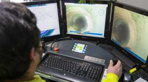
A set of applications from Cobra Technologies makes the interaction between pipe CCTV inspection and Esri ArcMap easy to use, requiring minimum user interaction for data exchange with complete detail in GIS maps. Users export inspections from the Cobra Toolbar into ArcMap to create prepopulated projects and linked maps, and supplement GIS data with additional infrastructure detail. During review the user will have access to the inspection video to allow for comparison of the data against the video file. ArcMap tools allow for filtering on the map and color coding CCTV inspections using the inspection date, observation type (e.g. roots), inspection status (e.g. completed, abandon) and PACP ratings. The GIS module for the pipe inspection management software assists municipalities in managing sewer and stormwater infrastructure using GIS data. 800/443-3761; www.cobratec.com.
Push TV Camera Systems - CCTV GIS connection application
Oct 23, 2014
| by Craig Mandli |