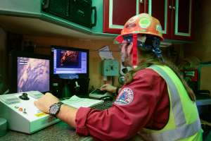
WinCan VX sewer assessment software
When integrated with Esri’s ArcGIS platform, WinCan VX sewer assessment software allows for navigation and analyzing of inspection data using a rich GIS interface. Map features can be linked to section and defect information, or a tabular record in an inspection can be clicked on to jump immediately to its mapped location. With this bidirectional link between GIS and WinCan, inspections can be prepopulated with data residing in GIS, eliminating manual data entry. The ArcGIS integration allows for filtered results, report creation, browsing of media and building of heat maps according to defect type or severity. 877-626-8386; www.wincan.com.
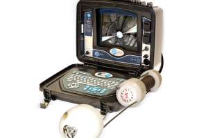
CUES Pullback Inspection Camera System (PICS) borehole inspection camera
The CUES PICS 2- to 4-inch borehole inspection camera helps eliminate cross-bores in directional drilling operations. The PICS is compatible with the entire CUES cross bore inspection platform that includes GraniteNet Gas software, sewer main and lateral inspection, and robotic lateral launch for pre- and post-inspection of sanitary and storm laterals. In addition, it features sonde and line locating, digital video and picture recording, and wireless integration with GraniteNet asset management software. 800-327-7791; www.cuesinc.com.
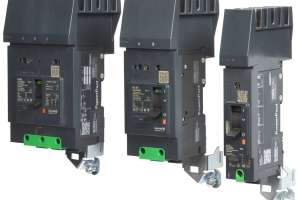
Schneider Electric PowerPact B circuit breaker
Schneider Electric’s PowerPact B-frame circuit breaker replaces the legacy FA/FH Series with upgraded features, including an expanded amperage range of 15-125A, and field installable accessories, while keeping the same mounting space dimensions. Everlink wiring lugs maintain constant contact with fine-stranded conductors, and every breaker includes a QR code to provide access to online product information and customer care center contact information. The breakers meet global electrical standards including UL, CSA, NOM, IEC and CCC. 888-778-2733; www.schneider-electric.us.
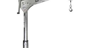
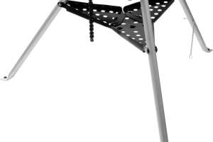
Reed Carry Light tripod vise
The Carry Light R450PAL tripod vise from Reed is designed primarily for plastic pipe loads, and its aluminum legs reduce the carrying weight, making the vise ideal for weight-critical field use. The reversible double-sided bow tie jaws have a neoprene side for plastic pipe and steel jaws on the other side for metal pipe. The chain vise adjusts to pipe and odd-shaped work pieces, and a straight cranking handle is included. A cushioned handle grip is positioned so the folded tripod can be carried at the balance point. Sides on the folding tray keep tools and parts safe from falling or rolling off the edge. 800-666-3691; www.reedmfgco.com.
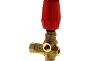
Water Cannon Inc. - MWBE Easy Start Unloader Plumbing Kit
The Easy Start Unloader Plumbing Kit from Water Cannon Inc. - MWBE ensures water goes where it should, and keeps excess water inside the pressure washer. The pre-assembled unit includes a brass valve body with a stainless steel ball and seat. It adjusts from 100 up to 5,650 maximum psi and has an easy-to-adjust ergonomic handle that features a tamper-resistant setting. The kit has two inlet and bypass ports and a built-in easy-start feature so the pump can start without static backpressure. It must be mounted in a vertical position. 800-333-9274; www.watercannon.com.
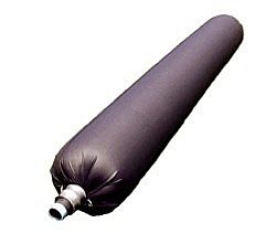
Petersen Products Multi-Flex CIPP Packer/Carriers
Multi-Flex CIPP Packer/Carriers from Petersen Products are available for virtually any diameter and length using ambient, hot water and steam cure. There are standard items as well as many custom configurations. They are available with or without a flow-through bypass. A fixed, inflated diameter — independent of the pipeline — bridges across broken sections of pipe, allowing for a continuous, smooth repair. The small-deflated diameter, lightweight, and flexibility makes for easier installation and removal through a small opening and confined or manhole spaces. 800-769-4973; www.petersenproducts.com.
Continue reading for free