It sometimes seems as if sinkholes appear overnight, swallowing sections of road and infrastructure without warning. But the reality is that these problems often develop slowly with the warning signs hidden below the surface. The best defense against sinkholes is a proactive inspection program and a solid emergency response program for if/when they do occur.
Understanding sinkholes
Not all sinkholes are created equally. In karst landscapes, sinkholes can form naturally over time as groundwater erodes limestone or other soluble rock. Meanwhile, infrastructure-related sinkholes can occur even in non-karst regions and are triggered by issues like a water main break washing soil out from under pavement; a collapsed sewer line creating a void underground that can migrate upward; poor grading or uncontrolled runoff eroding soils around buried infrastructure; or failed stormwater systems that allow water to escape and create cavities. In any of these cases, displaced or eroded soil gets worse over time until the surface above eventually gives way. A comprehensive inspection program should consider both causes, especially since the interaction of natural geology and failing infrastructure creates the highest risk.
There are a few principal risk factors to keep in mind regarding sinkholes. Aging infrastructure is a major factor, as many cities are relying on pipes that were installed 50 or even 100 years ago. While clay and brick pipes are especially vulnerable, even older concrete and metal lines can deteriorate to the point of collapse. Another risk factor is poor drainage, as areas with inadequate stormwater infrastructure or poorly graded surfaces can see repeated washouts, which increases the risk of soil erosion around utilities. Sandy soils, loose fill or areas with fluctuating groundwater levels are also prone to subsidence.
One thing that bears keeping in mind is that sinkholes are rarely random. They typically have an underlying cause tied to infrastructure or ground conditions, and those causes leave evidence that crews can use as they investigate problems.
Infrastructure’s role in sinkhole formation
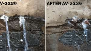
While natural karst processes are a driver of sinkholes, municipal infrastructure failures are increasingly recognized as local triggers. As outlined above, subsurface void formation is often connected to leaks from deteriorated sewer, water and stormwater systems. When a joint fails or a pipe wall is breached, hydraulic forces can displace surrounding soils. It can happen gradually or acutely, but the upshot is a loss of bedding support that leads to surface depressions or full-scale sinkholes.
Real-world examples regularly demonstrate the mechanics of this process. During heavy storms, a stormwater culvert operating under high pressure might force water through the surrounding soil. A failure in a sanitary sewer system might lead to exfiltration and erosion — a problem that is more severe when high groundwater levels allow already saturated soil to be carried into damaged pipes. In a pressurized water system, even a small leak acts like an underground pressure washer, continually blasting away soil and carving out a cavity that grows larger very quickly. And once the ground is too weak to support the weight above it, collapse is inevitable. Heavy traffic or a big rainstorm is often the last straw.
For asset managers, the implication should be clear: accurate and timely pipeline inspections are necessary for sinkhole prevention. Proactive crews that catch small leaks or defects before they worsen not only are able to prevent sinkholes, but also the larger costs and hazards that come with them.
Emergency response and containment
Sometimes, despite your best efforts, a sinkhole occurs, and you need to respond immediately to protect public safety and mitigate further damage to infrastructure. In those cases, the first priority is site security, which means isolating the area with barricades and rerouting traffic. Field crews should locate underground utilities right away to identify potential hazards, and they also should document conditions at the site, taking note of soil loss patterns and visible structural issues.
Your response to a sinkhole should also extend beyond field operations, as transparent communication with the public helps reduce risk and maintain trust. That includes clear messaging about detours and expected timelines. In the case of sewer/water service disruptions, advance notification and rapid release of boil-water advisories helps the public prepare.
Response efforts can be broken down into short-term stabilization and long-term repair phases. In the short term, flow bypass pumping, soil backfilling or rapid-fill grout may be deployed as a temporary solution to control void expansion and maintain service. Long-term remediation requires a full structural evaluation, permanent infrastructure rehabilitation and ground stabilization.

Inspection and monitoring
An effective inspection and monitoring program is the primary defense against sinkholes that are caused by underground infrastructure problems. To identify high-priority areas, consider proximity to critical roadways or places where there’s elevated risk of sinkholes, like older pipe networks, areas with shallow cover, or areas with a history of prior collapses. Also think about soil conditions and groundwater levels, as both of those will influence the odds of soil movement.
When you’re conducting inspections, there are certain visual indicators that signal an early-stage collapse risk. Look for things like offset or misaligned joints, evidence of infiltration/exfiltration, visible cavities near connections and structural cracking (which can compromise bedding support). In stormwater systems, seeing fine soils in a pipe often indicates there’s ongoing erosion outside the pipe somewhere.
Inspection technologies are always progressing, and there are now more tools than ever to support a comprehensive inspection and monitoring program. CCTV remains a cornerstone of condition assessment in sewer, stormwater and water systems, while laser profiling (used in dry pipe) or sonar profiling (used in water-filled pipe) can create a detailed map of a pipe’s interior. Acoustic leak detection can pinpoint leaks by listening for the specific sound frequencies created by pressurized water escaping a pipe. Ground-penetrating radar can be deployed from the surface to map voids and soil irregularities around pipelines. Data streams from all these methods collected by software like ITpipes SmartVision, can be integrated into Esri GIS and asset management systems, allowing municipalities to prioritize interventions and reduce the risk of sinkholes.

Municipal decision-makers often believe they can’t afford to budget for advanced monitoring and analytics platforms like SmartVision software, but the greater expense is what happens when they don’t. Utilizing different procurement channels can often be helpful when trying to secure infrastructure funding. A single sinkhole incident can run into the millions once emergency repairs, traffic disruptions, property damage and liability claims are factored in, and these costs dwarf the modest investment in preventative tools. Just in the last year, we’ve seen expensive sinkholes in Bowling Green, Kentucky, Montgomery, Texas, and Statesville, North Carolina. Using software to detect early warning signs allows utilities not only to extend the life of their assets but also to avoid the steep costs of an emergency response. Looking at it from this angle, preventive technology is less a luxury and more a fiscally responsible strategy.
Leveraging data and AI for prediction
Collecting and organizing inspection footage is only half the battle. Consistent coding and maintenance planning utilizing inspection data is an additional challenge, and that’s where data-driven tools like ITpipes AiDetect come into play. AiDetect combines AI-powered automation with human oversight to cut review time by at least 50%, delivers 97% defect detection accuracy and ensures NASSCO-compliance, all while seamlessly integrating into your current asset management and GIS systems. By automatically identifying high-risk defects and applying consistent coding, automation helps crews avoid the subjectivity that can creep into manual reviews.
Having documented historical inspections on hand allows you to see patterns in the data, recognize recurring leak sites or pinpoint soil movement, which allows for predictive maintenance planning. Instead of reacting after the pavement caves in, crews can prioritize proactive repairs in at-risk areas.
And with the added value of integrating an inspection software, like CoreVision, with a GIS platform, managers and crews can see these high-risk areas visualized on a map, which not only helps for proactive planning purposes, but also helps justify capital spending decisions with clear evidence.
Long-term mitigation and planning
Municipalities prepared to invest and plan ahead to prevent sinkholes will be well-positioned to address weak spots before they turn into emergencies. That includes budgeting for a diligent inspection program to attend to high-risk areas, and ensuring that crews are equipped to address the cause of the problem rather than just the symptom.
As an example, a utility might conduct a complete risk assessment on its infrastructure every five to 10 years to identify high-risk zones as outlined above. Routine monitoring can then follow a tiered structure where pipes might be inspected every few years in low-risk areas, annually in moderate-risk areas, and twice annually in high-risk areas. While major capital projects like new pump stations may require geological surveys to evaluate stability, routine inspections can focus on the first 20 feet below the surface where utility-related sinkholes most commonly develop.
While your crews know pipes inside and out, collaboration with geotechnical engineers is often necessary to offer insight into how soil and groundwater movements affect structural stability. Working together, you’ll have a more complete understanding of how to deal with sinkhole risks.