


Infrastructure mapping has become the top priority at the Department of Watershed Management (DWM) at DeKalb County, Ga., which is working to complete a detailed Geographic Information System map of its expansive sewer system, complete with Global Positioning Satellite coordinates, in just two years.
The county entered into a consent decree with the Environmental Protection Agency in December 2011, in which the EPA ordered the county to upgrade its infrastructure and reduce its sanitary sewer overflows. Part of that decree instructed the county to accelerate an infrastructure-mapping program that fully assesses the county’s sewer assets.
“Our sewer collection system was mostly built in the ’60s, ’70s and ’80s, so it’s now 25 to 50 years old on average,” says Ted Rhinehart, former deputy chief operating officer with DeKalb County’s Infrastructure Group of Departments. “While we find most of the pipes are structurally sound, there is need for rehabilitation and repair to extend their life and reliability.”
The pipe materials are about half PVC, about one-fourth reinforced concrete, and about one-fourth ductile and cast iron.
The primary cause of SSOs isn’t the condition of the infrastructure itself — it’s the system’s reduced capacity.
“We have very few I&I or structural issues,” says Rhinehart. “Most of the SSOs — about 75 percent — are related to build-ups of fats, oils, and grease and deposits of debris. The completion of a more precise GIS map of the system will create a model that will validate the fact that any capacity issues have been eliminated. Most of the solution to reducing SSOs will be regular system cleaning, public education on FOG and prevention. But the map will also provide us with an asset management tool for the prioritized sewer cleaning, maintenance and repair programs to follow.”
DeKalb County lies largely east of Atlanta, although it includes about 10 percent of the city. Its DWM is responsible for water, sanitary sewers and wastewater treatment.
The county has worked to expand and formalize assessment and rehabilitation of the wastewater collection system since 2006, when it experienced a record number of SSOs. The person in charge of the current accelerated mapping effort for the county is Darren Eastall, engineering supervisor and member of the GIS/GPS/data management staff with the DWM.
“The EPA consent decree concentrated on developing both the sewer mapping program and a capacity, management, operation and maintenance program,” says Eastall. “However, the mapping program will inform the CMOM program. The GIS sewer mapping is the foundation for so many of the consent decree programs that it was explicitly pushed to the top of our ‘to do’ list by the EPA. It’s put a lot of pressure on our department to perform.”
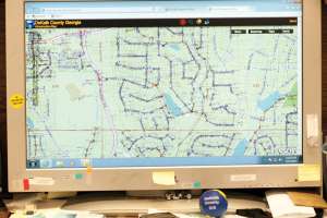
The county has had GIS capability since about 2002. Before the consent decree it had completed GIS mapping of part of the system’s 2,600 miles of sewer lines, some sewer assessment and detailed mapping of forcemains and lift stations. It had assessed the condition of more than half of its 55,000 manholes and found that more than 94 percent had no structural defects and only a small number of the remaining 6 percent required significant rehabilitation.
“With this program we are actually locating and surveying the sewer lines, checking the connectivity, design capacity and the pipe invert elevations, which were never captured in the CAD effort,” says Eastall. “The CAD files were based on ‘as-builts’ and plans, but there wasn’t always a confirmation that the lines were located exactly where we believed them to be. While we knew some of the GIS information, the information was kept in a separate database — it wasn’t yet a true GIS system.”
The DWM refined the scope of its accelerated mapping program in early 2012. Because it was clear that capacity, not infrastructure degradation, was the chief contributor to SSOs, some of the detailed assessment was postponed.
“We made it purely a mapping and capacity exercise,” says Eastall. “That’s not to say that we don’t ask for and acknowledge any obvious problems that might be reported. If something is wrong, we’ll deal with it, but it isn’t the prime driver for the program at this point. We want survey grade maps, including GPS coordinates and general conditions of each manhole, coordinates of pipe sites, grades, pipe inverts and digital photos of manholes and any other surface features.”
In order to complete the redefined $15 million mapping program by December 2014, the DWM is contracting out the survey work. The county had already contracted the Atlanta branch of the engineering firm of Brown and Caldwell to complete the preliminary assessment of the system in an initial five-year agreement that expired in 2012.
The current accelerated program has been divided among three contractors working simultaneously on one-year contracts. Brown and Caldwell has been retained, as has Arcadis US Inc. and Woolpert Inc. The selection process for the contractors was designed to ensure that the county received the best value for its money, despite the imminent demand for outside services.
“We went through a request for proposal process and had the proposals assessed by a selection committee that included our purchasing and contracting staff,” says Eastall. “We started with seven proposals, interviewed the top five, and then contracted with the top three candidates.”
Eastall says effective communication is the key to working with multiple contractors on a project of this scope.
“It’s essential to convey to them exactly what you expect and the form that the data they collect is going to take,” he says. “You also need to be available to listen to and act on their feedback.”
Each contractor is also provided with a detailed set of standard operating procedures to complete its tasks.
Each contractor is assigned to a sewer shed, divided into areas containing an approximately equal number of manholes. Contractors are provided with the original CAD surveys, then sent out into the field. Work is generally structured to complete a particular geographic boundary. About a dozen members of the DWM are available to the survey teams and bring real-world experience with DeKalb’s infrastructure to the game.
“They’re not necessarily embedded with the contractor, but they’re on call to assist when necessary,” says Eastall. “That expertise with the system is essential and irreplaceable. They may be needed to help find a buried manhole or to act as a mediator when a citizen demands to know what the survey team is doing near their property.”
Contractors also send in reports of badly graded topography, or manholes with capacity obviously affected by grease.
“We have an in-house operations department that looks after the maintenance and repair of our pipes, so if there’s an immediate need for maintenance, they handle it,” Eastall says. “This additional information is already helping us to develop strategies for the next phase of the program.”
The software tools being used to complete the project include ArcGIS by Esri for mapping, and InfoNet and InfoWorks databases by Innovyze for system inventory and modeling. The project also employs the CMMS maintenance software package by Oracle and Microsoft Access database software.
At the end of each month, the data collected by contractors is submitted and incorporated into the overall GIS map. In some cases, the GIS data differs markedly from the original as-built data.
The GIS database is available to any employee with access to the Internet or county Intranet and is already finding champions.
“We immediately began to see that the system was being used by people from our operations group, our customer service group and our dispatch department,” says Eastall. “The GIS data is now part of their everyday tool kit and we’re being asked for more and more datasets, different types of data analysis, more tools and more layers of information on the GIS map.”
As the DWM works toward its 2014 completion goal, its GIS map continues to expand in functionality and detail, providing immediate benefits.
“What’s great about this is that the data arrives in a form that we can incorporate and use almost immediately,” says Eastall. “The GIS map is literally expanding before our eyes.”
Continue reading for free