Although floods are consistently ranked among the leading causes of natural disaster losses and fatalities, there has been a major gap in technology to help sense and anticipate flood risk on a global scale — until now. NASA’s Earth Science Applied Sciences Disasters program and the Pacific Disaster Center have joined forces — with funding from the Research Opportunities in Space and Earth Sciences — to develop and incorporate new flood monitoring and early warning technology within PDC’s DisasterAWARE platform. It's a milestone in its partnership, which started in August of 2019.
PDC is an applied research center managed by the University of Hawaiʻi that develops new technologies and best practices to advance the field of disaster mitigation, preparedness, response and recovery. This new capability will support disaster management operations around the world.
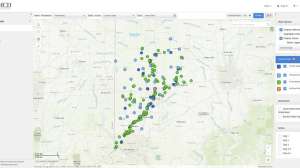
During the recent extreme flooding that impacted New South Wales, Australia, in March 2021, surpassing record levels from the last half century, Geoscience Australia on behalf of Emergency Management Australia engaged NASA’s Disasters program to help monitor floods. Using NASA’s newly developed remote sensing technologies and models, and PDC’s DisasterAWARE hazard monitoring and early warning system, officials were able to make more informed disaster response decisions by quickly understanding flood severity and extent.
“By combining (different flood) models, we can find where models agree, and increase the confidence of the final output for decision makers,” says PDC’s Deputy Executive Director Chris Chiesa.
Serving the global community
This new capability will be operationalized to serve an entire global community of end-users who use PDC’s DisasterAWARE.
“By integrating these new capabilities into DisasterAWARE, the NASA-derived information is able to reach decision makers with timely, life-saving information that will anticipate major flood events with the potential for widespread impacts to populations and infrastructure,” Chiesa says.
DisasterAWARE is used by tens of thousands of disaster management professionals, and the Disaster Alert mobile app has been downloaded nearly 2 million times.
Future developments
According to PDC Automation and Modeling Lead Greg Hampe, next on the radar for the global flood modeling partnership with NASA is new machine learning technologies that will help provide hyper-localized flood early warning and analysis.
“Applying machine learning tools to the model outputs will yield a focused and unified picture of flood risk. The results of this approach constantly improve over time as more data become available to ‘train’ the machine learning algorithm,” Hampe says.
At present, there is no single flood hazard modeling capability providing early flood warning for the entire globe, according to Hampe.
NASA Earth Science Applied Sciences Disasters program and PDC are also actively collaborating on a global landslide detection and early warning technology as part of its common objective to save lives, property and critical infrastructure around the world. These are expected to be operationalized in DisasterAWARE by the end of 2022.
Continue reading for free