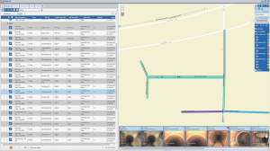
With the addition of the PipeLogix GIS Module added to ArcMap, supervisors can view all surveys performed on an asset. The toolbar filters survey data in the master database to highlight pipes with selected conditions, grades or score values, allowing the user to link to the video or survey. Survey conditions can be exported to a shape file or a geodatabase feature class. When opened in ArcMap, this layer displays the condition along the length of pipe. Selecting the condition will link to the video and jump to the correct footage for viewing. Seeing the problem and its location can make it easier to schedule repair and cleaning crews. It is compatible with ArcGIS 9.3 through 10.3. 866/299-3150; www.pipelogix.com.