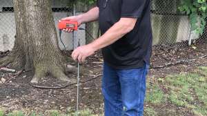
The Spar 300 from Vivax-Metrotech is a precise utility surveying system that collects positions to site coordinates. It continuously logs the utility depth and offset, along with statistical confidence and automatic offset calculations. It outputs the 3-D positions to a Trimble TSC3 for real-time display on the Trimble Access map. During complex locating scenarios, it applies automatic tolerance masks to the position data, flagging these areas on the map. By only keeping casual contact to the underground utility line, the system logs geospatial positions and expected error of the utility regardless of the perspective of the spar relative to the line. FieldSens Technology is based on the joint optimization of data from sensors against a physical model of the magnetic field expected from a utility line. The method minimizes the need to bring the measurement equipment to specific points related to the utility line in order to validate position. 800/446-3392; www.vivax-metrotech.com.